plants
Farm Pond and Small Dam Construction
Farm Pond and Small Dam Construction - comprehensive guide from Nored Farms.
Content Extraction Summary
Hook Options
Most farm ponds that fail were built correctly on paper. They fail because the person running the sheepsfoot roller didn't hit 95% Proctor density on every lift, or because the spillway was sized for a 25-year storm in a 100-year storm watershed. The engineering is straightforward — the execution is where ponds live or die. NRCS data shows that over 70% of embankment pond failures trace to either inadequate spillway capacity or poor compaction during construction, not to flawed design (USDA-NRCS, 2005). A well-built half-acre pond in clay soil with proper spillway sizing will outlast the person who built it.
Key Mechanism
An earthen dam is a gravity structure. It resists water pressure through sheer mass. The compacted clay core creates an impermeable barrier, the embankment shoulders distribute load, and the anti-seep collar prevents water from following the path of least resistance along any pipe penetration. When water finds a channel through or under the embankment — called piping — it erodes from the inside out, invisibly, until the dam collapses. Every design detail exists to prevent that single failure mode.
Misconception to Correct
People assume a pond is basically a hole in the ground that fills with water. An embankment pond is a dam — a regulated structure in most states once it exceeds certain height and storage thresholds. The embankment, spillways, and drainage structures are engineered components with specific material specs, compaction requirements, and legal obligations. Treating a pond like a casual excavation project is how people end up with a liability, a mudhole, or both.
Practical Application
Before breaking ground, dig three test pits across the proposed pond basin to at least 6 feet deep. If any pit shows less than 20% clay content by weight (determined by hydrometer test or the ribbon test — soil that rolls into a ribbon 2+ inches long before breaking), the site will leak without amendment. This single test saves more failed pond projects than any other step.
Citation-Ready Claims
- [Embankment failure causes] → [>70% attributed to spillway inadequacy or poor compaction] → [USDA-NRCS Conservation Practice Standard 378, 2005]
- [Compaction requirement] → [95% Standard Proctor density] → [ASTM D698; NRCS Engineering Field Handbook Ch. 6]
- [Clay content threshold] → [minimum 20% clay for natural seal] → [NRCS Ponds — Planning, Design, Construction (Ag Handbook 590)]
- [Spillway sizing] → [principal spillway for 25-yr storm, emergency for 100-yr] → [NRCS TR-60 Earth Dams and Reservoirs]
- [Dam safety regulation thresholds] → [typically 6 ft height + 15 acre-feet or 25 ft height] → [ASDSO State Dam Safety Program summaries]
A six-inch rainfall on 40 acres of watershed delivers roughly 650,000 gallons of water. That water is going somewhere. A properly built farm pond captures it, stores it, and releases the excess in a controlled path. A poorly built one stores it until the embankment gives way and sends all of it downstream at once. The difference between those outcomes is not complex engineering — it is clay content, compaction density, and spillway math.
Farm ponds serve more simultaneous functions per dollar than almost any other land improvement. Livestock water supply independent of wells and pumps. Gravity-fed irrigation reserve. Fire suppression source — rural fire departments routinely draft from farm ponds when hydrants don't exist. Aquaculture production. Wildlife habitat. Erosion control through watershed retention. Recreation. A single well-sited, well-built pond addresses all of these without ongoing energy inputs.
The USDA Natural Resources Conservation Service has been engineering and funding farm ponds since the Dust Bowl era. Their design standards (Conservation Practice Standard 378 and Agricultural Handbook 590) represent decades of field-tested specifications refined by tens of thousands of completed projects. Nearly everything in this article derives from those standards.
Site Selection
Site selection determines whether you build a pond or a money pit. Two factors dominate: soil composition and watershed geometry.
Soil Testing
Dig test pits — minimum three, spread across the proposed pond floor and dam footprint. Go at least 6 feet deep, ideally to the depth of your planned pond bottom. You are looking for two things: clay content and consistency.
**Clay content.** The NRCS standard for a naturally sealed pond is a minimum of 20% clay content by dry weight throughout the basin and embankment borrow area. Test this with a hydrometer analysis (ASTM D422) for precision, or use the field ribbon test: take a moist soil sample, roll it between your palms into a ribbon. If it holds together for 2 inches or more before breaking, clay content is likely adequate. If it crumbles at under 1 inch, the soil is too sandy or silty to seal without amendment.
**Consistency.** A test pit that shows clay for 3 feet then hits gravel or fractured rock is worse than uniform sandy loam. The gravel layer becomes a drain. Look for uniform, fine-textured soil through the full depth. Avoid sites with visible limestone karst features — sinkholes, springs, disappearing streams. Karst terrain can swallow entire ponds.
**Soil horizons to watch for:**
- CL (lean clay) and CH (fat clay) — both suitable for embankment cores and natural seal
- ML (silt) — compressible, poor shear strength, problematic in embankments
- SM and SP (silty sand, poorly graded sand) — will not seal, will not compact reliably
- GW, GP (gravel) — drains freely, unsuitable for pond basins without synthetic liners
Watershed Analysis
A pond needs water coming in and controlled water going out. The drainage area — the land that sheds runoff into your pond — must be large enough to fill the pond but not so large that storm flows overwhelm your spillways.
**Drainage area to pond surface area ratio.** NRCS guidelines recommend a minimum ratio of 4:1 (4 acres of watershed per 1 acre of pond surface) in humid climates receiving 35+ inches of annual rainfall. In semi-arid regions (under 25 inches), ratios of 10:1 to 20:1 may be necessary. These ratios ensure the pond fills in a normal year without requiring supplemental water.
To delineate your watershed, walk the ridgelines around your proposed pond site. Every drop of rain that falls inside those ridgelines will eventually flow toward your pond. Use USGS topographic maps or LiDAR elevation data (free from the USGS 3DEP program) to map the watershed boundary accurately.
**Springs and base flow.** A spring-fed site provides constant inflow independent of rainfall — ideal for livestock water and aquaculture. Measure spring flow rate during the driest month on record. A spring producing 5 gallons per minute delivers 7,200 gallons per day — enough to sustain a half-acre pond against summer evaporation losses of roughly 4,000–6,000 gallons per day in the southern US.
Topography and Pond Type
**Embankment ponds** (the most common farm pond type) are built by damming a natural draw, hollow, or drainage swale. The topography does most of the work — you build a dam across the low point, and the valley behind it fills. These are by far the most cost-effective because you're moving the least amount of dirt relative to storage volume. Ideal sites have a narrow outlet (short dam) with a broad, gently sloping valley behind it (large storage).
**Excavated ponds** are dug into flat or nearly flat ground. They cost more per acre-foot of storage because every cubic yard of capacity requires a cubic yard of excavation. They're used where topography doesn't offer a natural dam site, or where a smaller pond is needed close to buildings and corrals.
**Combination ponds** use excavated material to build an embankment on the downhill side, combining excavation depth with dam height. Most practical farm ponds use some version of this approach.
Design
Sizing: Surface Area, Depth, Volume
Pond sizing starts with intended use and works backward to dimensions.
**Livestock water.** A 1,000-pound beef cow drinks 12–20 gallons per day depending on temperature and lactation status. A herd of 50 head needs 600–1,000 gallons daily. Factor in evaporation losses — 0.2 to 0.3 inches per day in summer across the southern US — and plan for the driest 90-day period without significant rainfall. A half-acre pond averaging 8 feet deep holds roughly 1.3 million gallons. That provides approximately 130 days of supply for 50 head at peak consumption with evaporation, assuming zero inflow — a comfortable margin.
**Irrigation reserve.** One acre-inch of irrigation water equals 27,154 gallons. A 1-acre pond 10 feet deep (average) stores roughly 3.26 million gallons, or about 120 acre-inches — enough to provide supplemental irrigation to 10–15 acres through a moderate drought.
**Aquaculture.** Minimum depth of 8 feet at the deepest point (below the principal spillway) to maintain thermal stratification and adequate dissolved oxygen in summer. Surface area of at least 0.5 acres for meaningful fish production. Channel catfish stocking rates of 1,500–3,000 fingerlings per surface acre are standard for unfed or supplementally fed systems.
**Volume calculation for irregular shapes:**
- Rectangular approximation: Length x Width x Average Depth x 7.48 (gallons per cubic foot)
- For embankment ponds with sloping bottoms: use the prismoidal formula or estimate average depth as 40–60% of maximum depth
- 1 acre-foot = 325,851 gallons = 43,560 cubic feet
Embankment Dimensions
The embankment is the dam. Its geometry is dictated by structural requirements, not aesthetics.
**Top width.** Minimum 8 feet for dams under 10 feet high. Minimum 10–12 feet for dams 10–20 feet high. If the top will serve as a road or equipment crossing, minimum 12–16 feet with gravel surfacing.
**Side slopes.**
- **Upstream face (water side):** 3:1 (horizontal to vertical) minimum. This means for every foot of dam height, the upstream slope extends 3 feet horizontally. The flatter slope resists wave erosion and provides stability against rapid drawdown — when pond levels drop quickly, the saturated embankment loses the counterpressure of water against it.
- **Downstream face (dry side):** 2:1 minimum, 2.5:1 preferred. Steeper than upstream because it doesn't face wave action, but must still resist slope failure from internal saturation.
**Freeboard.** The vertical distance from the normal water surface (set by the principal spillway elevation) to the top of the dam. Minimum 1 foot for ponds under 0.5 acres. Minimum 2–3 feet for larger ponds. Freeboard prevents wave action from overtopping the dam during storms.
**Settlement allowance.** Build the embankment 5–10% higher than design height. All earthen fills settle as they consolidate under their own weight over the first 1–3 years.
Core Trench
The core trench is the most critical and most frequently omitted component in farm pond construction. It is a trench excavated into undisturbed soil along the centerline of the dam, beneath the full length of the embankment, then backfilled with compacted clay.
**Purpose.** It keys the compacted fill into the native subsoil, eliminating the interface between fill and native ground where water would otherwise seep. Without a core trench, the dam sits on top of the original ground surface — water migrates along that boundary until it exits on the downstream face, carrying soil particles with it. That is piping, and piping destroys dams.
**Dimensions.** Minimum 2 feet deep into undisturbed clay or impervious material. Minimum bottom width of 4 feet. Sides sloped at 1:1 minimum to allow equipment access for compaction. The trench must extend into both abutments (the hillsides on each end of the dam) far enough to reach impervious material.
Anti-Seep Collars
Any pipe that penetrates the embankment (principal spillway barrel, drain pipe) creates a potential seepage path along the outside of the pipe. Anti-seep collars — concrete or metal collars cast or welded around the pipe at intervals — force seepage water to follow a longer, more tortuous path, reducing velocity and preventing piping.
**Spacing.** NRCS standards require collars at intervals not exceeding 14 times the minimum collar projection, placed along the full length of the pipe within the saturated zone. Typical collar projection is 2 feet beyond the pipe diameter on all sides. Minimum of two collars for any pipe penetration, more for longer pipes.
**Material.** Reinforced concrete is standard. Minimum 6-inch thickness. Collars must be poured around the pipe with watertight contact — no voids, no gaps. Filter diaphragms using sand and gravel zones are an alternative approved by NRCS in some designs.
Spillway Design
Spillways are the single most consequential design element. An undersized spillway converts a controlled pond into an uncontrolled flood during a major storm event.
Principal Spillway
The principal spillway sets the normal water level and handles routine storm runoff. The standard design is a **drop-inlet riser and pipe** system.
**Riser.** A vertical pipe or box structure set at the designed normal pool elevation. Water rises to the top of the riser and flows over or into it, then down through a horizontal barrel pipe that passes through the base of the embankment and discharges on the downstream side. Corrugated metal pipe (CMP), reinforced concrete pipe (RCP), or HDPE pipe are common barrel materials.
**Sizing.** The principal spillway must pass the peak discharge from a 25-year, 24-hour storm event without the water surface rising above the emergency spillway crest. NRCS Technical Release 60 (TR-60) provides the design methodology, which accounts for watershed area, soil type, land cover, antecedent moisture conditions, and time of concentration.
**Trash rack.** A grate over the riser inlet prevents debris from clogging the barrel. Use heavy-gauge welded steel or cast iron. Space bars 4–6 inches apart. The trash rack must be large enough that partial blockage does not reduce capacity below design flow.
**Barrel pipe diameter.** Minimum 6 inches for very small ponds, but 8–12 inches is practical for most farm ponds. Pipe material must resist corrosion for a 50+ year design life. CMP with bituminous coating is common but deteriorates in acidic soils; RCP is more durable but heavier and harder to install; HDPE is increasingly preferred for chemical resistance and flexibility.
**Outlet protection.** The barrel discharge must be protected against erosion. A riprap apron — 12–24 inches of angular rock extending 6–10 feet beyond the outlet — dissipates velocity and prevents scour. Without it, the discharge erodes a hole beneath the pipe outlet, undermining the embankment toe.
Emergency Spillway
The emergency spillway handles flows that exceed the principal spillway's capacity. It is a broad, shallow channel cut through undisturbed earth on one abutment (side hill) of the dam — never through the embankment fill itself.
**Sizing.** Must safely pass the peak discharge from a 100-year, 24-hour storm event (or greater, depending on dam hazard classification). For high-hazard dams — those where failure would threaten lives or major infrastructure downstream — the emergency spillway may be sized for the probable maximum flood (PMF).
**Key design parameters:**
- Bottom width: typically 20–50 feet for farm ponds, wider for larger watersheds
- Depth: 1–3 feet at the control section (the shallowest point of the spillway crest)
- Side slopes: 3:1 minimum
- Grade: gentle slope away from the dam, with velocity controls (grade breaks, riprap, turf reinforcement) as needed
**Vegetation.** The emergency spillway channel must be established in dense, erosion-resistant turf before the pond fills. Bermuda grass, bahia grass, or native sod-forming grasses are standard. Bare soil in an emergency spillway guarantees erosion damage during the first major storm event.
**Exit channel.** The spillway must discharge to a stable outlet — an existing waterway, rock outcrop, or armored channel — not onto the downstream slope of the dam or into an unprotected swale that leads back toward the embankment toe.
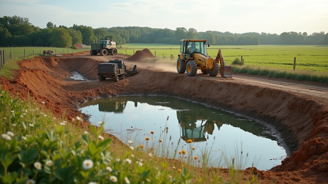
Construction
Site Preparation
**Clearing.** Remove all trees, stumps, roots, brush, topsoil, and organic material from the dam footprint, core trench alignment, and borrow areas. Organic material buried in a fill decomposes, creating voids and settlement. Stumps left in the foundation are future piping paths. Strip topsoil and stockpile it for later use on embankment slopes and spillway channels.
**Staking.** Mark the dam centerline, core trench alignment, embankment toe on both sides, spillway locations, and borrow area boundaries with stakes and flagging. Survey the foundation grade after stripping to confirm it matches the design cross-sections.
Core Trench Excavation
Excavate the core trench to the specified depth and width along the full dam centerline. The bottom must reach impervious material — typically a clay layer that will resist seepage. If no clay is encountered at the design depth, the trench must go deeper or the design must be revisited.
Scarify (roughen) the trench bottom and sides before backfilling. Smooth, compacted surfaces left by the excavator bucket create slip planes. Roughened surfaces bond better with the compacted fill.
Compaction
Compaction is the single most important construction operation. The standard is **95% of Standard Proctor maximum dry density** (ASTM D698). This is not optional, not approximate, and not something you eyeball.
**Lift thickness.** Place fill in horizontal layers (lifts) no more than 6–8 inches thick (loose measurement) before compaction. After compaction, each lift should be 4–6 inches thick. Thicker lifts cannot be compacted to the required density by any equipment.
**Moisture content.** Soil must be within 2 percentage points of optimum moisture content for compaction. Too dry: the soil won't bond between particles, and density stays low regardless of roller passes. Too wet: the soil becomes plastic and deforms instead of densifying, and excess pore water pressure develops. Test optimum moisture in the lab (Proctor test) before construction begins, and test field moisture regularly with a nuclear density gauge or sand cone method during placement.
**How to judge moisture in the field without a lab:** Take a handful of fill material and squeeze it firmly. If it holds together in a ball and shows a slight sheen of moisture but doesn't ooze water between your fingers, it is near optimum. If it crumbles apart, it needs water. If water drips from the ball, it needs to dry.
**Equipment.** A sheepsfoot roller (also called a padfoot roller) is the standard compaction tool for cohesive (clay) fills. The protruding feet knead and densify the soil from the bottom of the lift upward. Smooth drum rollers are less effective on clay because they seal the surface before the lift interior is compacted. For small ponds where a sheepsfoot isn't available, a loaded scraper or dozer making multiple passes provides partial compaction — but density testing becomes even more critical.
**Number of passes.** Typically 4–8 passes with a sheepsfoot roller per lift to reach 95% Proctor. The exact number depends on soil type, moisture, lift thickness, and roller weight. Density testing confirms results.
**Bonding between lifts.** Before placing a new lift, scarify the surface of the previous compacted lift to a depth of 1–2 inches. This breaks the smooth compaction surface and creates mechanical interlock between lifts. Smooth lift interfaces are planes of weakness and potential seepage paths.
Embankment Placement
Build the embankment in horizontal lifts across the full dam width. Do not build one section to full height and then build the adjacent section — this creates vertical joints (cold joints) that are seepage paths. The entire dam rises uniformly.
**Zoning.** In a zoned embankment, the impervious clay core occupies the center, with more permeable (but more stable) shell material on the upstream and downstream shoulders. This allows the use of less-than-ideal borrow material for the outer zones while concentrating the best clay in the critical core. For simple homogeneous dams (all one material), the entire fill must meet impermeability and compaction standards.
**Pipe installation.** Install the principal spillway barrel pipe as the embankment rises around it. The pipe must be bedded on compacted fill (not loose soil) and backfilled and compacted by hand in 4-inch lifts within 2 feet of the pipe on all sides. Equipment compaction near the pipe risks crushing it or creating voids beneath it.
Sealing
Not every site has adequate natural clay. Several proven methods exist for sealing a leaking pond or building a pond on marginal soil.
Compacted Clay Blanket (Natural Seal)
If the pond basin soil is inadequate but a nearby clay source exists, excavate 12–18 inches of the basin floor, replace with imported clay, and compact in lifts to 95% Proctor. Extend the clay blanket up the embankment face to at least 3 feet above normal pool elevation. This is the most cost-effective seal for large ponds when clay is available within a reasonable haul distance.
Bentonite Blanket
Sodium bentonite clay swells to 10–15 times its dry volume when hydrated, creating a nearly impermeable barrier. Application rate: 1–3 pounds per square foot depending on soil permeability, applied as a 2–4 inch layer mixed into the top 6 inches of the pond basin, then compacted. Cover with 6–12 inches of soil to protect the bentonite from drying, cracking, and disturbance by livestock or burrowing animals.
**Cost:** Bentonite costs approximately $150–$300 per ton delivered, depending on location. A half-acre pond at 2 lbs/sq ft requires roughly 22 tons — $3,300 to $6,600 in material before application.
Synthetic Liners
**EPDM (ethylene propylene diene monomer).** Flexible rubber membrane, 45 mil typical thickness for ponds. UV-resistant, fish-safe, handles substrate movement and freeze-thaw cycles. Seams joined with adhesive or tape. Best for smaller ponds (under 1 acre) where the cost per square foot is justified. Lifespan 20–30 years.
**HDPE (high-density polyethylene).** Rigid plastic membrane, 30–60 mil. More puncture-resistant than EPDM but less flexible — poor substrate conformance on rough or rocky surfaces. Seams require thermal welding (specialized equipment). Standard for waste lagoons and industrial ponds. Lifespan 30+ years.
**Installation requirements.** Subgrade must be smooth, free of rocks, roots, and sharp objects. A geotextile fabric underlayment protects the liner from puncture. Anchor the liner in a trench around the pond perimeter, backfilled with compacted soil. Cover the liner with 12–18 inches of soil or gravel to protect from UV degradation, animal damage, and mechanical abuse.
Sodium Bentonite Injection (Repair Method)
For existing ponds that leak through isolated seepage zones rather than wholesale porous soil, sodium bentonite can be applied to the water surface over the suspected leak area. The bentonite settles, hydrates, and fills voids and fractures. This is a repair method, not a primary seal. It works best for seepage through small cracks, joints in rock, or localized sandy zones.
**Application.** Broadcast granular bentonite at 1–2 pounds per square foot over the leaking area from a boat or the bank. Allow 2–4 weeks for full hydration and settlement. Repeat if necessary. Lower pond levels concentrate the bentonite over the leak zone and improve results.
Stocking and Management
Aquaculture Integration
A farm pond deeper than 8 feet with a surface area of at least half an acre supports productive fish culture. Standard warm-water polyculture in the southern US:
- **Largemouth bass:** 50–100 fingerlings per surface acre (predator control)
- **Bluegill sunfish:** 500–1,000 fingerlings per surface acre (forage base)
- **Channel catfish:** 100–500 per surface acre in balanced systems, up to 1,500–3,000 in fed monoculture
Stock bluegill first in fall, then bass the following spring or early summer. This staggers the size classes so bass don't immediately consume all the bluegill before the forage base establishes.
**Feeding.** Unfed ponds produce 100–300 pounds of fish per acre per year. Supplemental feeding (32% protein floating pellets) increases production to 1,000–3,000 pounds per acre per year depending on aeration and management intensity.
Bank Vegetation and Erosion Control
Bare embankment slopes erode. Wave action on the upstream face, rain on the downstream face, and foot traffic on both sides remove soil and weaken the structure over time.
**Upstream face:** Establish erosion-resistant turf grass. In high-wave-action zones (fetch greater than 200 feet or exposure to prevailing winds), riprap the upstream face from 2 feet below normal pool to 2 feet above with 6–12 inch angular rock on a geotextile filter fabric.
**Downstream face:** Dense turf grass — bermuda, bahia, fescue, or native sod-forming species. Mow regularly to maintain density and to allow visual inspection. Do not allow trees or large shrubs on the embankment. Their root systems create seepage channels through the fill, and windthrow (a tree blown over by wind) tears a crater in the embankment that can initiate piping.
Aeration
Ponds deeper than 8 feet in warm climates thermally stratify in summer — warm oxygen-rich water on top, cold oxygen-depleted water on the bottom. When the pond "turns over" (thermal layers mix due to cooling surface temperatures in fall), the oxygen-depleted bottom water mixes throughout, causing fish kills.
**Bottom diffused aeration** prevents stratification by continuously circulating water from bottom to top. A shore-mounted compressor pushes air through weighted tubing to a diffuser at the pond bottom. The rising bubbles entrain water and create circulation. Size the compressor at 1–2 CFM per surface acre minimum.
Depth Maintenance
Sedimentation is the primary threat to pond longevity. Eroding cropland, bare construction sites, or overgrazed pastures in the watershed deliver sediment that settles in the pond, reducing depth, volume, and function.
**Prevention.** Maintain vegetative cover on all watershed land. Establish a buffer strip of dense grass at least 50 feet wide around the pond perimeter to filter sediment from inflow. Diversion terraces upslope redirect concentrated flow away from the pond inlet.
**Remediation.** Dredging a silted pond is expensive — $3 to $10 per cubic yard depending on access and disposal. An ounce of sediment prevention in the watershed is worth a ton of dredging cure.
Safety and Common Failures
Piping (Internal Erosion)
The most dangerous failure mode. Water seeping through or under the embankment carries soil particles with it. The seepage channel enlarges progressively until the embankment collapses. The first visible sign is often muddy water emerging on the downstream face — by the time you see it, significant internal erosion has already occurred.
**Causes:** Inadequate core trench, poor compaction, animal burrows, decayed roots, gaps around pipe penetrations, dispersive clay soils (clays that deflocculate in water and are carried away as individual particles).
**Prevention:** Core trench into impervious material. 95% Proctor compaction on every lift. Anti-seep collars on every pipe. No trees on the embankment. Active muskrat and groundhog control.
Overtopping
Water flowing over the top of the dam erodes the downstream face rapidly and can breach the embankment within hours. Overtopping is caused by inadequate spillway capacity — the storm produces more runoff than the spillways can discharge.
**Prevention:** Size spillways correctly. Principal spillway handles the 25-year storm. Emergency spillway handles the 100-year storm or greater. Maintain freeboard. Keep the emergency spillway channel clear and vegetated. Never allow fill, fences, or debris to reduce the spillway capacity.
Slope Failure
The embankment slope slides downward, typically on the downstream face, due to internal saturation, excessive steepness, or foundation weakness. Slope failures often occur during sustained high-water events that saturate the embankment.
**Prevention:** Maintain design slopes (3:1 upstream, 2:1 downstream minimum). Ensure proper internal drainage — a chimney drain or blanket drain on the downstream side of the core allows seepage water to exit the embankment safely without building pore water pressure. Avoid loading the embankment top with structures, stockpiled material, or heavy equipment.
Tree Roots in Embankments
Trees on earthen dams are a universal problem in aging ponds. Root systems penetrate the compacted fill, creating channels for seepage. When trees die or blow over, the decayed root channels become direct piping paths.
**Remediation.** Cut trees flush with the ground surface and treat stumps with herbicide to kill the root system. Do not pull stumps — ripping a root ball out of a dam leaves a crater that is worse than the root channels. Allow roots to decay in place while monitoring for seepage.
Muskrat and Burrowing Animal Damage
Muskrats burrow into embankments at and below the waterline, creating tunnels that can extend through the full dam width. A single muskrat family can riddle an embankment with tunnels in one season.
**Control.** Trap aggressively. Install wire mesh (hardware cloth) on the upstream face from 3 feet below to 3 feet above normal pool elevation during construction. Riprap on the upstream face also discourages burrowing. Inspect the dam regularly for burrow entrances.
Permits and Regulatory Requirements
Federal — USACE Section 404
Constructing a pond that involves filling or dredging in "waters of the United States" — including streams, wetlands, and their tributaries — requires a permit under Section 404 of the Clean Water Act, administered by the US Army Corps of Engineers. Most farm ponds built on intermittent drainages or dry land require only a Nationwide Permit (NWP), which has streamlined processing. Damming a perennial stream typically requires an Individual Permit with environmental review.
**Exemptions.** The Clean Water Act provides a limited exemption for construction of farm ponds in areas that are part of normal farming, ranching, or silviculture activities, provided the activity does not convert a wetland to dry land (Section 404(f)(1)(C)). This exemption is narrowly interpreted — consult with the local Corps district office before assuming it applies.
State Dam Safety Regulations
Most states regulate dams above certain size thresholds, typically defined by height and storage volume. Common thresholds (vary by state):
- **Height:** 6 feet (measured from downstream toe to dam crest) combined with storage exceeding 15 acre-feet
- **Height:** 25 feet regardless of storage volume
- **Storage:** 50 acre-feet regardless of height
Dams exceeding these thresholds require state permits, engineering design by a licensed professional engineer, construction inspection, and periodic safety inspections after completion. Some states (Texas, for example) exempt agricultural ponds below certain size thresholds from dam safety requirements but still require compliance with floodplain regulations.
Check your state's dam safety program — the Association of State Dam Safety Officials (ASDSO) maintains a directory at damsafety.org.
NRCS Assistance Programs
The NRCS provides both technical and financial assistance for farm pond construction through several programs:
- **EQIP (Environmental Quality Incentives Program):** Cost-share funding (typically 50–75% of eligible costs) for conservation practices including ponds for livestock water, irrigation, and wildlife habitat
- **Technical assistance:** NRCS district conservationists provide free site evaluation, soil testing, design assistance, and construction inspection for qualifying landowners
- **Conservation Practice Standard 378 (Pond):** The engineering specification document that governs NRCS-assisted pond design and construction
Contact your local NRCS service center (offices in most county seats) to begin the process. Lead times for design and funding approval can be 6–18 months — start the process well before you plan to break ground.
Sources
1. USDA-NRCS. *Ponds — Planning, Design, Construction.* Agriculture Handbook No. 590. United States Department of Agriculture, Natural Resources Conservation Service. Revised 2017. 2. USDA-NRCS. *Conservation Practice Standard 378 — Pond.* National Handbook of Conservation Practices. 2005 (updated periodically). 3. USDA-NRCS. *TR-60: Earth Dams and Reservoirs.* Technical Release No. 60. 2019 revision. 4. USDA-NRCS. *Engineering Field Handbook, Chapter 6 — Structures.* National Engineering Handbook series. 5. ASTM D698. *Standard Test Methods for Laboratory Compaction Characteristics of Soil Using Standard Effort.* ASTM International. 6. ASTM D422. *Standard Test Method for Particle-Size Analysis of Soils.* ASTM International (withdrawn 2016, replaced by D6913/D7928). 7. Association of State Dam Safety Officials (ASDSO). *State Dam Safety Program Directory.* damsafety.org. 8. US Army Corps of Engineers. *Clean Water Act Section 404 — Permit Program.* 33 U.S.C. 1344. 9. Swingle, H.S. *Relationships and Dynamics of Balanced and Unbalanced Fish Populations.* Alabama Agricultural Experiment Station Bulletin 274. 1950. 10. Boyd, C.E. *Water Quality in Ponds for Aquaculture.* Alabama Agricultural Experiment Station, Auburn University. 1990. 11. US Bureau of Reclamation. *Design of Small Dams.* 3rd Edition. US Department of the Interior. 1987.
`[practical-skills]` `[facility-design]` `[advanced]`